2021-09-22 16:53:39
Origin of name: YingGe, normally known as parrots in Chinese, got its name for it is believed to provide shelter for tens of thousands of red-breasted parakeets before, which was recorded in the book Explorations in the Hitherto Untraversed Island of Hainan. The author, Benjamin Couch Henry, an American missionary coming to China in 1882, witnessed the ubiquitous red-breasted parakeets around the Shiyun Town, Qiongzhong County.
Tourists can embrace the distinctive beauty of the steep mountains and fascinating scenery in the area all year round. In Yuanmen, we can experience the amazing grandeur of the Hongxin Waterfall or feel the changes of forest landscape on either side, which switches from artificial forest to secondary forest. In Nankai, we are able to stroll along the crystal clear streams, admire beautiful fishes, and learn the unique local customs of Li and Miao communities.

Tourists can also visit the site of the former headquarters of the Qiongya Column of the Special Committee of the CPC, who once fought for the liberation of the region. YingGe Ling is more than a gathering place of historic sites and cultural treasures. More importantly, it has presented the humanistic spirit of the new era. In the Yingge Lecture Hall, you can have a deeper understanding of how local people stay committed to their dreams and dedicated to a better future in the new era.
Location and area: YingGe Ling is located in the central and southern part of Hainan Island, right at the heart of Hainan Tropical Rainforest National Park. It is of great significance in the conservation of Hainan terrestrial forest ecosystem. The YingGe Ling area (109°7' 17.3712"E-109°34' 21.4104"E, 18°49'29.589"N-19°14'15.5364"N) encompasses Baisha County, Qiongzhong County, Ledong County, and Wuzhishan City, covering a total area of 861.7 km², with the general control area occupying 409 km² and core protection area, 452 km².
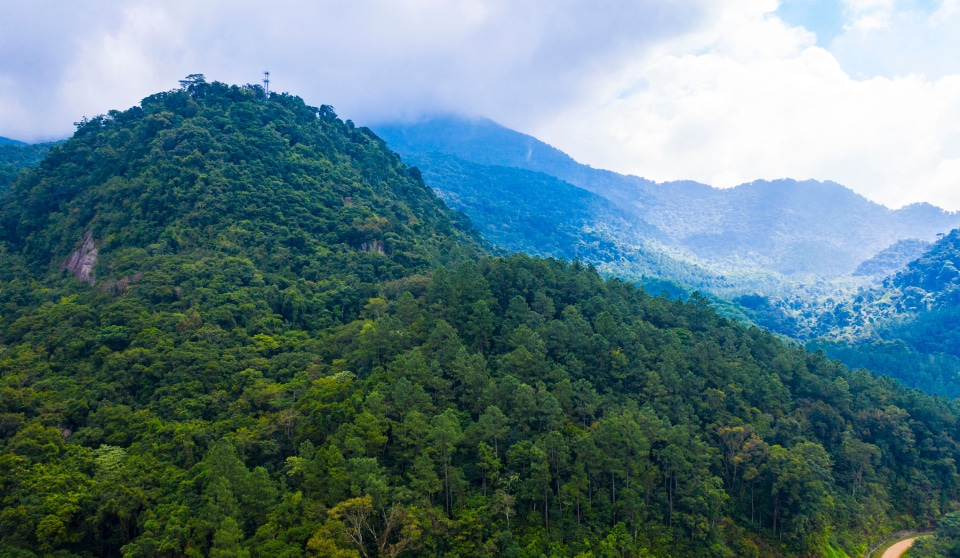
Geological landform: YingGe Ling and its surroundings were shaped more than 440 million years ago since the Ordovician to the Quaternary. The descending, sedimentation and violent orogenic movements have formed different types of sedimentary, magmatic and metamorphic formations, and tectonic equation. These geological relics show that the area has experienced two major transitions and three geotectonic development stages, recording a complex history of polycyclic tectonic evolution. Mountains largely occupy the YingGe Ling reserve. In the west are hilly and mountainous areas formed by metamorphic rocks and granite, with the rocks weathered and hills cut by water and valleys. By contrast, the central and eastern parts of the reserve are characterized by red rock beds, steep cliffs (at an incline of 40-50 degrees), thin soil layer and deep and narrow valleys. The highest peak YingGe Ling stands as tall as 1,812 meters, making it the second highest mountain in Hainan, 1,642 meters higher than the lowest point (170 meters) at the Nanlong River to the southwest of the EMei Shan.
Climate: The area has a tropical marine monsoon climate, which is mainly influenced by the advance and retreat of the subtropical high over the West Pacific in summer and the frequent invasion of winter continental monsoon during the winter half-year. The average annual temperature ranges between 20 ℃ and 24 ℃. In particular, the average temperature in July is 25-28 ℃, while that of January is 15-19 ℃. Annual average temperature over the area rises from northeast to southwest at the same elevation. In places below 400 meters, the annual average temperature of the South Slope is 0.1-2.0 ℃ higher than that of the North Slope, while in places above 600 meters, the figure for the North Slope is 0.1-2.2 ℃ higher than that of the South Slope. The area has abundant rainfall yet not evenly distributed in a year. The annual rainfall ranges from 1,800mm to 2,700mm on average; the average monthly rainfall is 30-400mm; and the relative variability is between 30% and 60%. It rains a lot from May to October, contributing to about 80% to 94% of the annual rainfall, and the annual amount of evaporation ranges from 1,600mm to 2,000mm. YingGe Ling experiences longer cold spells as the place is easier to trap cold air than discharging it. In colder years, the water in the North Slope and high-altitude zones becomes static and frozen. In the YingGe Ling area, places standing below 400 meters have typical tropical climate, where typical tropical rainforest grows on laterite; in the cool and humid zone at the elevation of 800-1,500 meters, or the transition zone between tropical and subtropical regions, the land is covered by mountain yellow soil on which montane rainforest and evergreen broad-leaved forest thrives; and at the peak above 1,400 meters high, the area is characterized by low temperature, high humidity, heavy cloud and mist, strong wind, steep slopes, thin soil layer, lower trees, curved trunks and branches with mosses.

Soil: Influenced by climate, vegetation and other factors, the YingGe Ling area shows obvious vertical zonation of soil. This hilly and mountainous area is dominated by granite and supplemented by some quartzite and amphibolite. The types of soil vary from mountain yellow soil to mountain lateritic red soil, laterite and partly mountain scrubby-meadow soil.
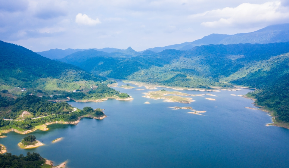
Hydrology: YingGe Ling is the main source of Nandu River and Changhua River, the first and second largest river in Hainan. It is also the watershed of these two basins. The North Slope belongs to the fan-shaped Nandu River system in which water converges into the Nankai River in Nankai Town, Baisha County, while the South Slope gives birth to the Changhua River system. In addition, some major independent branches on the northwest slope flow into the main stream of the Nandu River leading to Haikou city. The streams on the South Slope flow in parallel, across the mountain range and the trunk of Changhua River, and ultimately empty into the Beibu Gulf in the west. In YingGe Ling area, gullies are developed, and the surface is dissected by deep, long valleys and steep rivers. The water is fast flowing in the narrow river channel, with more rapids and falls observed. Atmospheric precipitation provides surface runoff water, while groundwater is stored in karst and basement faults. Rivers, streams and creeks in the area are mostly short, steep and fast-flowing in the bent channels, with a concentrated fall and small catchment area. They also experience high yet short flood peaks, higher risk of floods, and high ratio of maximum flow to minimum flow. This hilly area has undergone multiple periods of tectonic movements, from which folds and faults are well developed, and magmatic activities occur frequently. Mountains are drastically cut by narrow valleys, making it easy to form surface runoff, which is unfavorable to the occurrence of groundwater. As a result, the area is lack of groundwater.
Plant resources: YingGe Ling area is home to 2,323 species of vascular plants in 1,094 genera of 236 families, including 289 species of ferns and 2,034 species of spermatophytes. Among them, Hopea hainanensis, Bretschneidera sinensis, Cycas hainanensis and Cycas taiwaniana are protected at the national first-class level; 28 species of wild plants are protected at the second-class level, including Brainea insignis, Keteleeria hainanensis, Horsfieldia hainanensis Merr., Aquilaria sinensis, Dalbergia odorifera and Merrillanthus hainanensis; and 147 species are listed in CITES. Another 145 species and 14 species are listed in the China Plant Red Data Book and IUCN Red List of Threatened Species. Newly recorded plants include Dryopteris gemmifera, Munronia yinggelingensis, Cladopus sp., and Terniopsis daoyinensis.
Animal resources: A wide range of animals are also discovered in the area, including 512 species of vertebrates in 37 orders and 137 families (92 species of freshwater fish, 119 species of amphibious reptiles, 252 species of birds and 49 species of mammals). 9 first-class state protected animals inhabit the area, namely, clouded leopard, Hainan peacock-pheasant, Hainan partridge, water monitor, zibet and rasse. In addition, 65 animal species are placed under the second-class national protection.
At present, 1,607 species of 119 families of insects have been found in YingGe Ling, including 407 species of butterflies, among which Teinopalpus aureus is a national first-class protected species.
National Park of Hainan Tropical Rainforest
© Management Office of the National Park of Hainan Tropical Rainforest. All rights reserved.
Address: Forestry Department of Hainan Province, No.80, Haifu Road, Meilan District, Haikou, Hainan
ICP License No.: 琼ICP备17004007号-2
Hainan Networking Filing No.: 46010802000541
Website designed and developed by: Hinew.cn